Open-source software (OSS) is a software product for which the code is freely available to the public to use or modify. This is essentially the opposite from what we call proprietary software, which is privately owned and licensed. Open-source software may sound like something that would only be useful to an IT specialist or computer software engineer, but it is relevant to many of us in the ag industry, especially farmers. Open-source software is usually developed by a group of people who have a mutual interest in creating a software product that fits their specific needs and often avoids the high cost of similar pay-to-use products.
Many programs and software products we use are open-sourced; for example, Android, the world’s most popular mobile operating system is OSS. The web browser Firefox, the computer operating system Linux, and the programming language Python are all more examples of OSS used by millions of people today. While OSS projects have been popular in the computer science world since the 1990s, there has been little interest in projects related to agriculture until quite recently. As more farmers have now grown up in the age of computers and software development, we are starting to see an increase in open-source projects related to agriculture. Many of these projects aim to develop technology that doesn’t currently exist, avoids the high cost of existing proprietary technology, or fits a specific need not catered to by larger for-profit companies.
Ag Open GPS
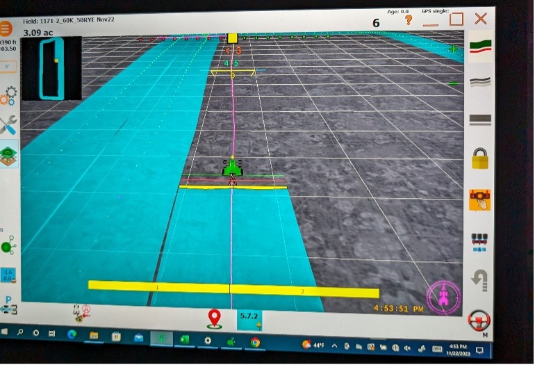
One of the most popular projects with tech-savvy farmers is Ag Open GPS. Ag Open GPS is a project started by Brian Tischler from Alberta, Canada. The project aims to provide an inexpensive auto-steer solution for farmers with all the functionality you might find in todays branded products. The software is completely free, only requires a generic GPS antenna, receiver, and Windows tablet to run as a conventional lightbar with a coverage map. This setup will achieve pass-to-pass accuracy of <1.5m although, in personal experience, it is better than this in the Midwest. Adding RTK corrections via NTRIP or a radio base station will allow for <1cm accuracy. Adding a circuit control board and a few other components allows for auto-steer functionality with the same accuracy. Additional functions include section control, automatic implement lift, and more in development.

Figure 1: Ag Open GPS utilized as a lightbar/coverage map
Farm OS
Farm management software is also a growing sector of ag technology and has a well-developed OSS option called Farm OS. This application is designed for farmers and farm workers to easily access and record farm operations. Farm OS operates as a web application which means it must be hosted on a server of your own, or you must pay some small annual fee to host it on another server. The advantage to it being a web app and not a static Excel document means farmers can integrate sensors and real-time data logging into the application.
Web ODM
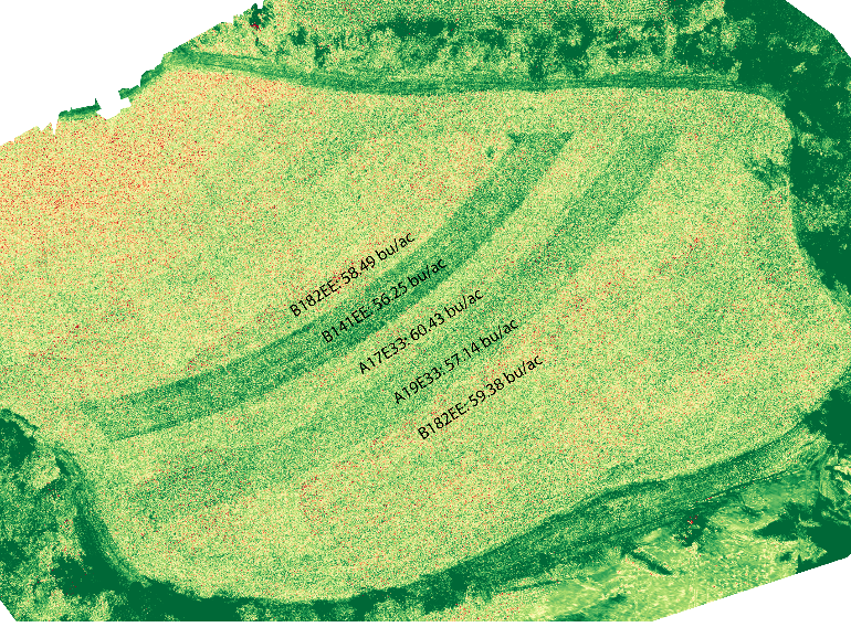
Web ODM (Open Drone Map) is an OSS that makes combining individual drone images to form larger high resolution orthomosaic images for analysis, easy and available for anyone. Commercial options for the same process can cost more than $1000 a year for a subscription. Web ODM can analyze an image with plant health indicators such as NDVI, LAI, and many more.

Figure 2: Web ODM used to combine UAV images and measure NDVI
Open Weed Locator
Open Weed Locator is a project started by PhD student Guy Coleman to detect and spray individual weeds in a fallow field environment. All software and hardware design plans are freely available. In crop weed detection is currently in development.
ArduPilot
Drones are one of the hottest topics in agriculture today and many of them are flying with a software that is adapted from one of the most successful open-source projects. ArduPilot is a drone or UAV fight control software. ArduPilot has been around a long time and did not start as an ag related project but today many drones built for commercial and hobby use are utilizing the ArduPilot software in some way.
Conclusion
While many of these projects lack the customer support and user-friendliness of a commercial product, if you are a tech-savvy farmer, or have tech-savvy kids, the cost and functionality may be worth it. As a bonus, you won’t be stuck paying or waiting for service since you will likely be stuck doing any fixing yourself.
Disclaimer: Any use of trade names is for descriptive purposes and does not represent an endorsement by the author. None of the products mentioned here have been evaluated or are endorsed by UW–Madison.
Written by Sam Bibby


